

Route 5 Corridor/Marion Hill Study
Project Status: Completed
Start Date: May 2017
Actual End Date: December 2018
Magisterial District: Varina
On Tuesday, December 11, 2018 the Henrico County Board of Supervisors adopted the Route 5 Corridor Study. The goals, objectives, strategies and design guidelines have been incorporated into the 2026 Comprehensive Plan. A copy of the final report is available below, as are answers to Frequently Asked Questions compiled during the study.
Project Description
Henrico County’s 2026 Comprehensive Plan identified both Route 5 (New Market Road) and Marion Hill as Special Focus Areas that warrant further study because of certain characteristics, challenges or opportunities.
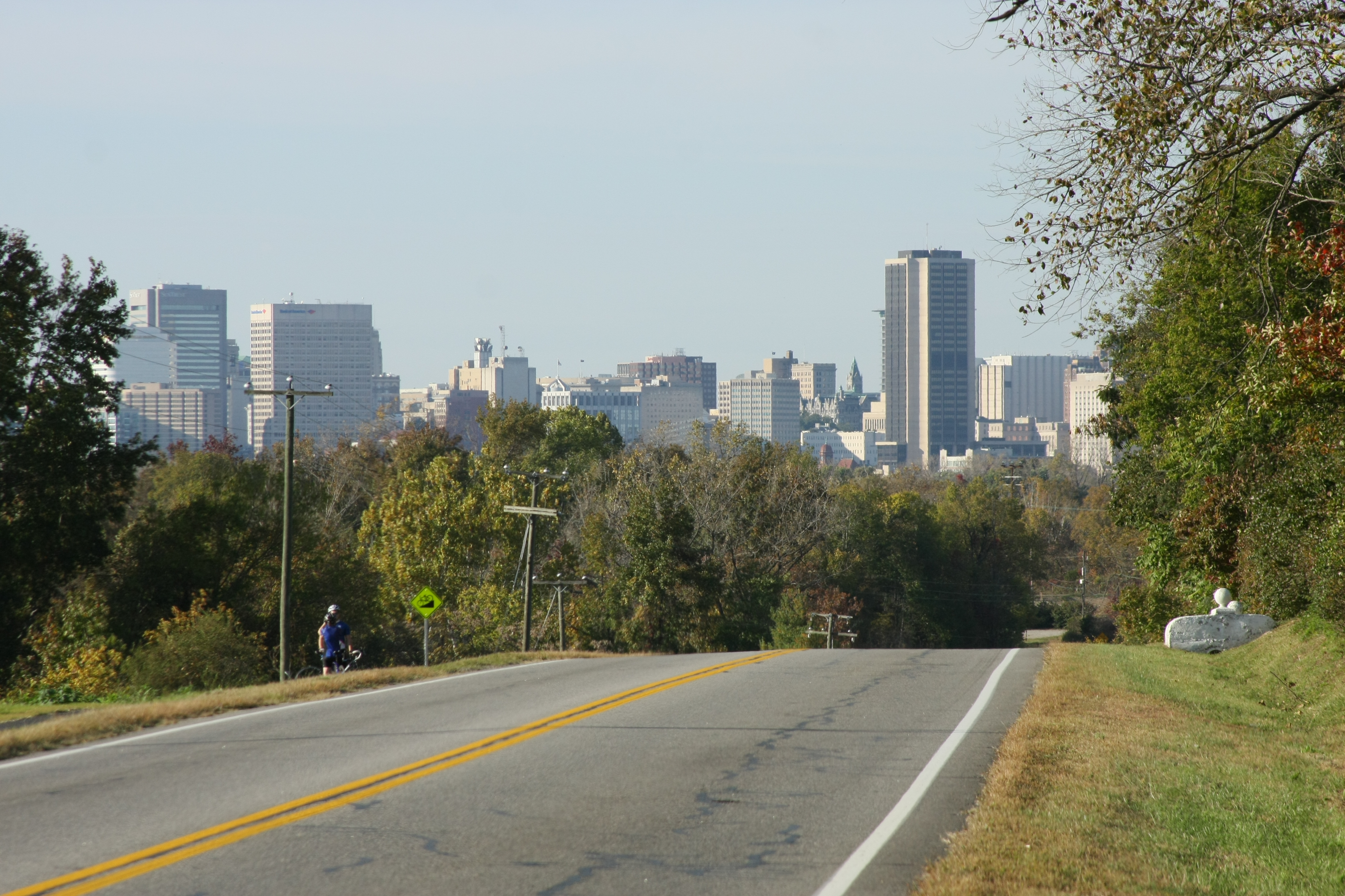
In Henrico, Route 5 is a state-maintained road approximately 14 miles in length that runs from the eastern boundary of the City of Richmond through the Varina Magisterial District to Charles City County. The Marion Hill neighborhood shares a boundary with Route 5 and, due to its close proximity, will be studied in conjunction with the Route 5 corridor. Development adjacent to Route 5 has historically been rural in nature but has evolved in large part to more suburban style single-family developments amidst small farms and large-acreage homes. On March 14, 2017, the Board of Supervisors directed the Planning Department to initiate a study for the Planning Commission’s review and recommendation to the Board regarding possible Comprehensive Plan amendments.
The corridor study area extends 500 feet on either side of the centerline of Route 5. This includes 878 parcels and 1,409 acres. It will be the longest corridor plan undertaken in Henrico County.
The purpose of the study is to evaluate the existing character of both focus areas and offer recommended guidelines for use in future review of development proposals, while integrating and respecting the existing agricultural, residential and commercial development currently present along the corridor. Data was compiled on previous studies, existing conditions, and visual conditions. That information can be found below in the document entitled Draft Route 5 Corridor Study.
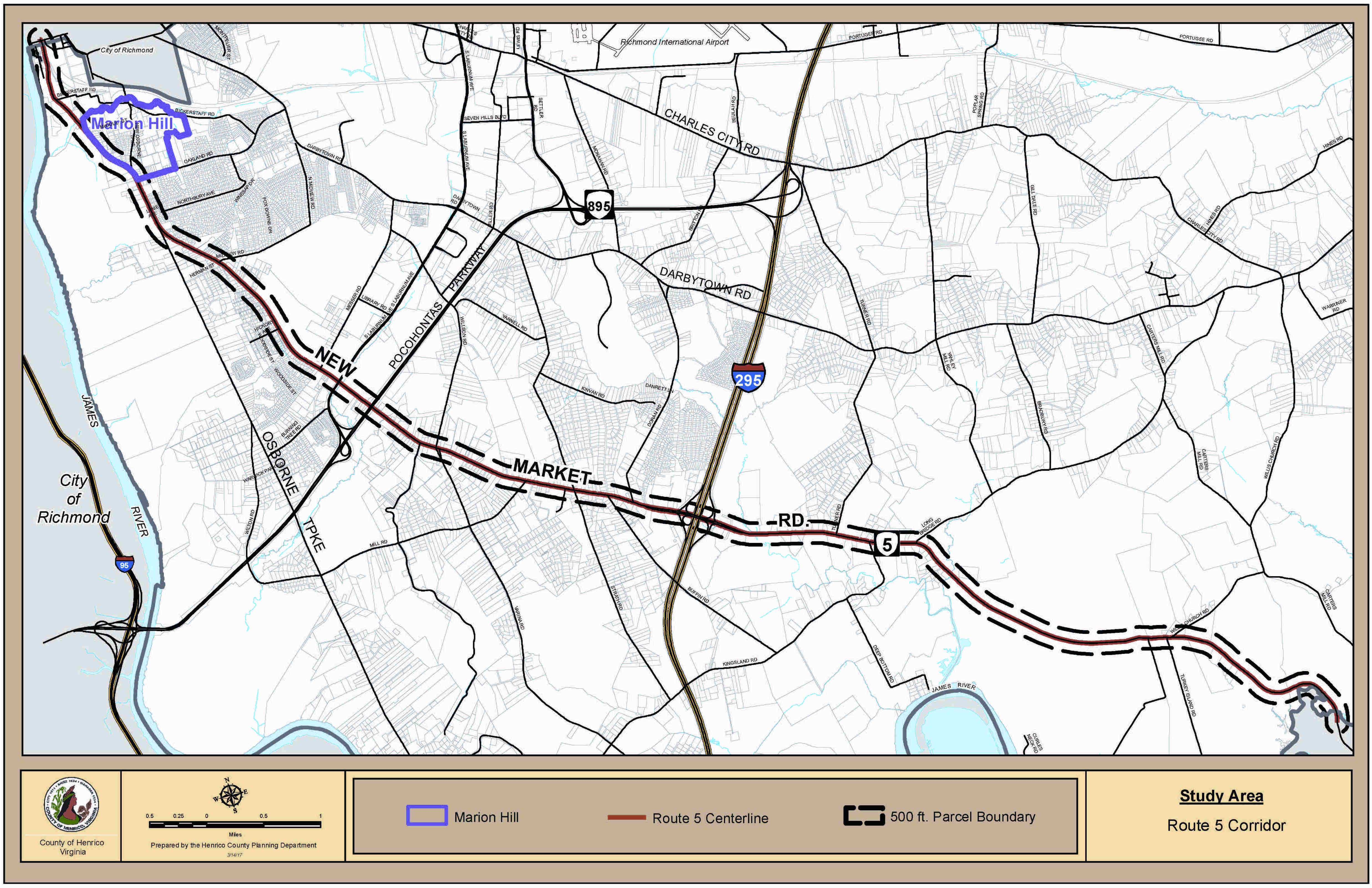
PLEASE NOTE: The Marion Hill neighborhood has been removed from the Route 5 Corridor Study. During the previous open house and community meetings, residents raised concerns about the neighborhood’s unique characteristics, and how they differ from the Route 5 corridor. Staff has determined an independent study is appropriate and will be completed at a later date. For further information regarding this study, please contact Rosemary Deemer at (804) 501-4488 or via email.
Route 5 Corridor/Marion Hill Public Engagement Portal
The goal of the Public Engagement portal is to provide additional opportunities for citizens and stakeholders to participate in the study and to provide a platform for your comments. It includes a short community survey and a new feature – a public input map where you can pinpoint and comment on opportunities/strengths and challenges along the Route 5 Corridor. These suggestions will be labeled directly on the Corridor Study Map. The portal also includes a virtual tour to help you get started and reacquainted with the corridor.
Progress to Date
- On Thursday, May 11, 2017 Planning staff kicked-off the project with a presentation to the Henrico County Planning Commission. Approximately 25 residents, stakeholders and representatives from local community organizations attended the meeting to heard a brief overview of existing conditions and the proposed framework for the study. Following the presentation, several individuals shared their thoughts about the corridor, and surrounding neighborhoods, with the Planning Commission.
- Also on Thursday, May 11, 2017 the Planning Department introduced a project-specific website and public engagement portal.
-
The Planning Department hosted an Open House at the Varina Library from 4:30 to 7:30 p.m. on June 8, 2017. Varina residents and other members of the public were welcomed to view background information compiled by staff for the Route 5/Marion Hill Study. Over 110 people attended, asked questions, shared their thoughts, and made comments via an exit survey.
There were a variety of maps and graphics displayed throughout the room, including segment maps showing aerial photography, zoning and Future Land Use designations. Other maps depicted recreation/park facilities, historic markers and conservation properties, the Major Thoroughfare Plan, parcels falling within the 500-foot study boundary and existing views and vistas. Graphics of various cross-sections throughout the corridor and suggested sub-areas based on differing character and land uses along the 14-mile long corridor were also provided.
Attendees also had an opportunity to provide feedback via an Exit Survey. Based on a review of the responses, most participants were interested in Future Land Use recommendations and the Major Thoroughfare Plan, as seen on the chart below:
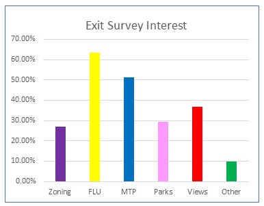
A copy of the maps, and a summary of comments from the Exit Survey can be found by scrolling to the bottom of the page and clicking on the links for the Open House Graphics and the Open House Survey Results.
-
On Thursday, August 3, 2017 a Community Workshop was held at John Rolfe Middle School. Over 100 residents gathered for an overview of the Draft Route 5/Marion Hill Study document. The Planning Department’s facilitator, Greg Dale, also discussed how input is used to formulate goals, objectives and strategies. Attendees were then assigned to work tables and asked to identify their 5 most important issues facing Route 5 and Marion Hill. Participants were also encouraged to label such examples on a map of the area. Approximately 70 individuals remained to participate in this portion of the workshop.
Each table presented their ideas to the larger group. Staff recorded them and sheets of the shared ideas were then hung on the walls. The workshop concluded with participants using a dot voting technique to identify those issues/concerns they most agreed with. The chart below indicates which topics garnered the most votes.
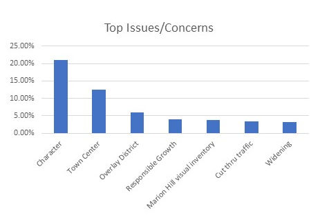
A copy of the evening’s agenda, PowerPoint presentation, and a complete list of comments and pictures of the dot sheets can be found in the Documents section.
The input received from the community workshop, as well as the June Open House and the Web Survey, are being used to draft goals, objectives and strategies for the corridor and Marion Hill.
-
On Wednesday, September 27, 2017, staff presented an update to the Planning Commission on public participation efforts conducted for the study. A summary of website activity was provided, including total number of “hits” to-date and an analysis of most-commented upon topics from the dedicated survey and public input map. Staff also provided information on the number of attendees and top issues/concerns shared at the June Open House and the Community Workshop held in August.
The presentation used for the Planning Commission briefing is available by scrolling to the bottom of the page and clicking on the appropriate link.
On Thursday, October 19, 2017, a second Community Workshop was held at John Rolfe Middle School. Over 110 residents and interested members of the public attended. The Planning Department’s facilitator provided a summary of the results of public input received to-date. This was followed by a brief review of the framework used to develop goals and objectives.
The remaining portion of the workshop was spent gathering feedback on a series of draft goals and objectives, as well as design preferences. Attendees were each provided with a hand-held keypad device and asked to indicate their level of agreement for statements or images in the presentation. The results were displayed on-screen within seconds. The exercise was also used to obtain feedback on general architectural style-preferences for the future design of a restroom facility to be constructed at the Four Mile Creek Park trailhead parking lot.
As the workshop concluded, attendees were asked to identify a place along the corridor they could envision as a town center. This was in response to comments received at the August community workshop suggesting the development of such a use.
A copy of the presentation for the keypad polling exercise, including the responses, the meeting agenda and images of the town center mapping exercise, can be found at the bottom of the page.
Many of the goals and objectives were overwhelmingly agreed upon, while others were thought to be “vague” or “leading”. The town center concept was particularly discussed at length. In response to the feedback and as an effort to simplify, clarify, and streamline the goals and objectives, staff reviewed all the comments received throughout the public participation process.
This included the 59 exit surveys, 118 online survey responses, 30 public input map comments and 3 letters, plus the original worksheets (13) from the August goals/objectives/strategies brainstorming exercise. The five issues below were identified as the most frequently commented upon.
- Character (rural, agricultural, historic)
- Land Use
- Tourism
- Transportation (Route 5 & Capital Trail)
- Recreation
-
Using these topics and feedback, staff revised the goals and objectives, and identified corresponding strategies. A summary document explaining how the goals, objectives and strategies were revised and how they are intended to be implemented can be found by scrolling to the bottom of the page and clicking on the appropriate link.
-
On Monday, June 4, 2018 the Planning Department hosted an Open House at the Varina Library from 4:30 – 7:30 p.m. to gather feedback on new and revised information pertaining to the study. Following a complete review of all comments received throughout the public participation process, staff revised the previous goals and objectives, identified corresponding strategies and developed draft design guidelines. The information was made available on the website prior to the open house.
Over 140 attendees gathered to review the maps, graphics and text displayed throughout the room and discuss issues and concerns one-on-one with staff. In addition to the above-mentioned items, an exhibit of the various architectural style found in the Route 5 area was displayed, as were cross-sections illustrating the various sub areas with recommended setbacks and landscaping.
Participants also had an opportunity to offer feedback via a Citizens Comment Sheet. Based on a review of the initial responses, most attendees were supportive of the information provided. Several comments reflect the misconception this study proposes to widen Route 5 or encourages future residential or commercial development. Neither is true. The purpose of the study is to evaluate the existing character of Route 5 to determine how future development proposals, should they occur, integrate the current agricultural, residential and commercial development present along the corridor.
The Virginia Department of Transportation (VDOT) currently has 2 proposed projects in the study area. A public information meeting was held on January 16, 2018 for a pedestrian safety enhancement study for the Capital Trail. VDOT also held a public information meeting on May 15, 2018 to discuss turn lane improvements along Route 5 at Buffin Road.
A copy of the Revised Draft Goals, Objectives and Strategies, Draft Design Guidelines, Architectural Styles, Cross-Sections and Citizen Comment Sheet can be found at the bottom of the page, under Documents.
-
At their Thursday, July 12, 2018 work session, the Planning Commission received a presentation from staff on the status of the Route 5 Corridor Study. Staff reviewed the purpose of the study, existing conditions, public participation milestones and feedback, as well as recommended goals, objectives, strategies and potential design guidelines.
A copy of the July work session presentation can be found at the bottom of the page, under Documents.
-
At their Thursday, August 9, 2018 work session, the Planning Commission continued the discussion of the Route 5 Corridor Study. Planning staff presented suggested changes to the revised goals, objectives and strategies, and draft design guidelines received from stakeholders, as well as responses to each.
A copy of the August work session presentation can be found at the bottom of the page, under Documents.
-
The Planning Commission held a public hearing on the Route 5 Corridor Study on October 18, 2018 (rescheduled from October 11, 2018 due to inclement weather). At the request of the Varina District Supervisor, the meeting was held in in the auditorium of the New Bridge Learning Center at 5915 New Bridge Road in an effort to be closer to the study area. Approximately 85 citizens attended the meeting and 13 speakers offered public comments.
-
On November 8, 2018, the Planning Commission reviewed the comments received at their October public hearing and recommended the Route 5 Study on to the Board of Supervisors.
-
On December 11, 2018, the Henrico County Board of Supervisors adopted the Route 5 Corridor Study. The goals, objectives, strategies, and design guidelines were incorporated into the 2026 Comprehensive Plan as a plan amendment.